A thousand islands, a thousand colors. The islands of Sinan County, South Jeolla Province,
dotting the waters off the southwestern tip of Korea, make up a protected ecosystem rich in marine resources and endowed
with incomparable scenery. Indigenous knowledge accumulated over the thousands of years of humankind’s coexistence with
nature on these islands is a gift of immeasurable value to the future of Korea and the world.
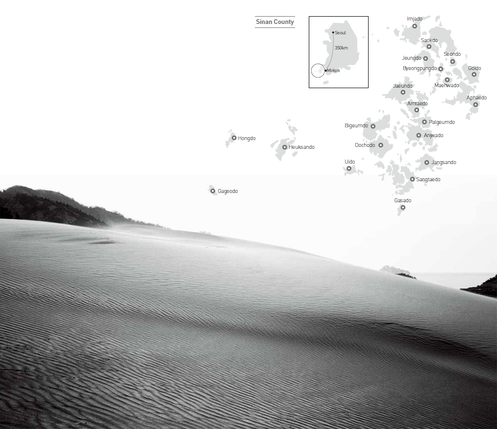
Grassland spreads on top of the cliffs, some 100 meters high,
on Seomdeung Peninsula on the island of Gageodo. Walk along the ridge to the end and you'll find yourself
at the most southwestern point of Korea.
For people who visit an island, every moment and every mile approaching the destination quickens with delicious anticipation of the exotic scenery, the wide open vistas of sky, land, and sea, and justifiable suspension of worldly concerns for a while. Island travel is a journey away from the humdrum of daily life tied down to the tyranny of the clock — from continuous time into non-continuous time — a return, as it were, into the nurturing womb of nature.
A visit to Sinan is such a journey, from the mainland to one island, and then another. Taking a boat out to the islands is like immersing in the warm waters and indigenous stories of their origins and the lives of the islands’ denizens.
The Coastal Islands
Among the numerous islands of the Sinan archipelago, Jido is most closely connected with the mainland. From here, Jeungdo and Saokdo are also connected by bridges, which means that these three islands at least can be reached without catching a boat. The diverse saltwater plants (halophytes) growing in the tidal flats of Jeungdo, designated a Ramsar site of international importance under the Convention on Wetlands, change from one brilliant colorto another with the changing of the seasons. The shipwrecked 14th-century Chinese cargo vessel, well preserved in the muddy seabed in the shallow seas
of Sinan to be recovered centuries later, is proof that this area has been along a strategic maritime route where trading ships have passed through since ancient times. Taepyung Salt Farm in Jeungdo, established on land reclaimed from the mudflats, and the stone salt warehouse that now serves as the Salt Museum, have been designated as Modern Cultural Heritages. The historical value of these sites is enriched with the stories of the salt workers abounding with their joys and sorrows.
Just 30 minutes by boat from Jeomam wharf at the western end of Jido is the Jin-ri wharf on Imjado, the northernmost island of Sinan County. The white sands of Daegwang Beach, 300 meters wide, stretch over 12 kilometers along the island’s coastline and can be covered in a leisurely walk of three or four
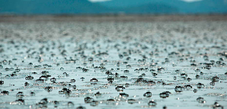
hours. It is because of this beach, the biggest in Korea, that Imjado is nicknamed Moraeseom, which means “sandy island.” From this beach, the tidal flats pulsing with life spread out seaward. Tiny crabs and myriad other forms of marine life squirm and burrow in the mud all night, forming small balls of sand
and drawing pictures on the golden shore. Carelessly, the sea comes rushing in, erasing the pictures and rushing out again. But the little artists have no time to rest. They continue their work, and without fail the golden sand is covered with new pictures the next day.
In April each year, an exotic spectacle unfolds along Daegwang Beach. Here the nation’s biggest tulip festival takes place with three million blossoms covering a park area of 120,000 square meters. The park, where 68,000 square meters is devoted to tulips and 52,000 square meters to pine trees, is a creative example of how natural resources can be utilized. The local government supported the suggestion by horticulture researchers at Mokpo National University, who said that tulips would flourish in Imjado’s rich sandy soil, abundant sunlight, and ample sea breezes. While the island is famed for its harmony of natural and manmade resources, and as a place where visitors can get away from the world for a while, few know that this park is a human creation. About half the island was originally underwater, but over a long period of time the local residents reclaimed land from the sea by building dikes to block off the seawater, and were eventually able to join six adjacent islands into one land mass. This island is scheduled to be connected to Jido by a bridge in 2020.
The salted shrimp of Jeonjangpo, in the northern part of the island, is recognized as the finest in Korea in taste and quality. The shrimp are caught around the sixth lunar month when they are at their plumpest, and packed in salt right on the boat. Crocks filled with salted shrimp are then stored in caves at the foot of a mountain behind the wharf-side village and left to slowly mature over a long time, as has been done by countless generations on this island. Flavored with local knowledge, which provides experienced and intuitive guidance, the salted shrimp produced here, known as “Jeonjangpo saeu-jeot,” well lives up to its reputation. These kinds of slow food and distinctive regional specialties come from traditions handed down through the generations.
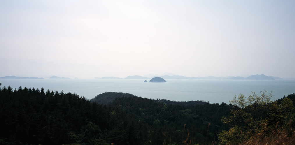
Looking over the water in the direction of Mokpo from the top of Sangsan Peak on Uido, the Sinan archipelago with its myriad islands forms a grand spectacle.
At the top of hilly Jangdo is a rare mountain wetland complex that is included in the Ramsar List of Wetlands of International Importance.
Diamond Cluster: Paradise for Migratory Birds
The islands in the central part of the Sinan archipelago form a diamond shape and are therefore called the “diamond cluster.” Some of the best-known islands of Sinan can be found here. This includes Bigeumdo, in the left-hand corner of the diamond, that is now noted as the hometown of go grandmaster Lee Se-dol, who recently played a series of historic matches against AlphaGo, an artificial intelligence computer system.
Some 10 kilometers southwest of Bigeumdo lies Chilbaldo, an island with a lighthouse known as a popular stopover for migratory birds. Early in the morning,the island is shrouded in mist and seems to be floating in the air. It must be navigated with extra caution so as to not run into the steep rocky cliffs. Designated a Natural Monument, this uninhabited island is a habitat for such migratory birds as the storm petrel, streaked shearwater, and fork-tailed swift, which visit here in winter to breed. It is particularly important as a habitat for 80 percent of the world’s storm petrel population. A key point along the East Asian–Australasian Flyway, which connects Siberia to Southeast Asia, it is also a valuable site for protection of a diversity of bird species. The nearby islands of Hongdo and Heuksando are also regular stopovers for the many migratory birds that fly through Korea, and every year some 300,000 birds of 271 species can be observed in the Sinan area.
The birds are attracted to the islands’ tidal flats. The tidal flats of Korea are considered to be among the most important in the world, along with those of
the Wadden Sea of the Netherlands, Germany and Denmark, the Georgia coast of the United States, the mouth of the Amazon River in Brazil, and the eastern shores of Canada. The county of Sinan, with its more than 1,000 islands, has the largest area of tidal flats in Korea. The high tides and low tides that occur twice a day create a fantastic panorama of islands sitting atop the tidal flats at every low tide, with tidal flats, tidal channels, and tidal waterways linked together in intricate networks. The tidal flats that stretch out expansively over the diamond cluster form a rich and complex ecosystem of mudflats, sand dunes, and islands, where a diverse variety of marine creatures provide food for the migratory birds.
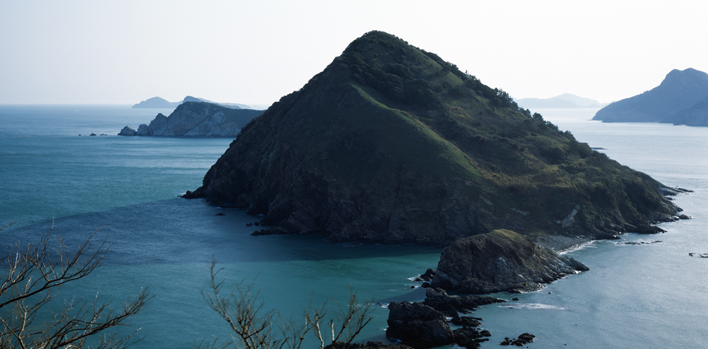
To the southwest of Dochodo is Uido, looking like a mound of rocks of varying sizes piled
on top of each other. This island is famed for Mt. Dori, covered in silver magnolia and camellia trees,
and the sandy beaches and steep golden sand dunes that create a seaside desert scene.
To the southwest of Dochodo is Uido, looking like a mound of rocks of varying sizes piled on top of each other. This island is famed for Mt. Dori, covered in silver magnolia and camellia trees, and the sandy beaches and steep golden sand dunes that create a seaside desert scene. Because of the significant decrease in the amount of sand in recent years, public access to the dunes is prohibited until 2020. Rocky hills sit on one side of the island, where on rainy days myriad waterfalls are formed, if only briefly. The island is especially pleasant for walking; it is about four kilometers from the western end to the eastern end. The peacefulness and friendliness of the island is palpable in the winding lanes, running from one village to the next, and the time-worn stone walls blackened with moss.
In 2018, the New Millennium Bridge is slated to open to link Aphaedo, the seat of Sinan County office which is already connected to the mainland, with Amtaedo on the upper side of the diamond cluster. Linking the islands of the diamond cluster with the mainland will fulfill the residents’ long-held desire
for greater convenience in their daily lives and easier access to cultural amenities. But, at the same time, development will bring about new problems since the distinctive characteristics of an island are best protected by the surrounding seas.
The sand dunes of Donmok Village on Uido present a different appearance every day according to the whims of the wind and rain. There is a saying that the women of Donmok must swallow several gallons of sand before they get married.
The Islands of the Open Sea
When the boat that departed from Mokpo Ferry Terminal passes by Bigeumdo and Dochodo, leaving behind the little islands scattered about, the wide open ocean spreads out as far as the eye can see. Passengers making the trip for the first time might be overcome with unease when leaving behind the islands that serve as a buffer against the relentless waves. But the high-speed ferry silently glides along the same time-tested route that maritime travelers have used to get around the archipelago.
The wide open seas are home to Heuksando, Hongdo, Gageodo, Damuldo, Jangdo and Manjaedo, among other islands. These are known as the Heuksan group of islands. Hongdo, called the pearl of Sinan, presents ever-changing scenery, not only through the four seasons but even over the course of a single day. Gageodo is a mystical place where rain and strong winds and waves can leave you stranded in the midst of a primeval forest for days; Jangdo features unique inland mountain wetlands; and Yeongsando boasts the “eight beautiful sights,” which include a stone archway rising out of the sea.
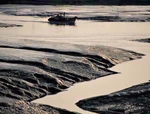
Manjaedo is perhaps the least-known jewel of this island group with its pebble beach lining the village, offering picturesque views in all directions. It is so small that there are no facilities for large boats to dock. To reach the island, you must take the boat from Mokpo and transfer to a smaller boat out on the open sea as it passes Gageodo on the way back to Mokpo, and then sail on for another kilometer. If the gods do not permit it, as the locals say, Manjaedo cannot be reached. Here, from the top of the hill at the end of the road that follows along the stone walls, the islands scattered over the surrounding waters come into view. Below the bright white lighthouse, the stone pillars on the cliffs gleam through the ocean spray and twilight, creating a spectacle every morning and night. The pebbled shore is where the fishermen work, drying their seaweed and dividing up harvests. The island’s haenyeo, or women divers, gather seaweed from the rocks along the shore and harvest the ocean’s various bounties. They know from experience that protection of the island’s environment and natural resources is the way to survive there.
Heuksando, though now mainly known for its skate fish, operated one of the three largest open-sea fish markets in Korea, along with Wido and Yeonpyeongdo. Open until the late 1970s, the markets featured different fish from month to month through the end of October. The yellow croaker markets opening from January to April and the whale markets from February to May were the pride of Heuksando. Records say that more than 500 boats would gather at these fish markets in the 1960s; indeed, this was the center of Korean fishermen’s “gold rush.” Archaeological evidence reveals that from the Unified Silla (676–935) to Goryeo (918–1392) periods, the island’s Eupdong Bay was a strategic point along the maritime trade route between China and Korea.
The Heuksan island group and uninhabited islands in the area are renowned for their thick groves of silver magnolia and camellia trees, the dominant species in Korea’s warm temperate zone where evergreen broad-leaved trees thrive. Under the influence of global warming, this area has become a battleground for survival between the broad-leaf and conifer forests. These islands are oneof- a-kind nurseries where changes in the climate can be examined so that possible changes in the local flora can be forecast.
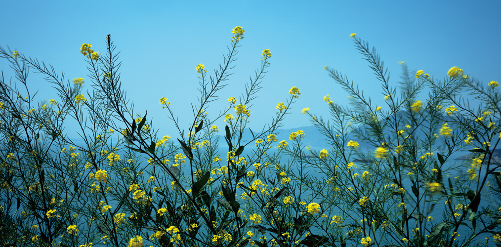
The rape flowers are in bloom on Anjwado, where the birthplace of Kim Whanki (1913–1974), a pioneer in Korean abstract art, is preserved.
Key to Sustainability
On board the boat to leave the islands, my head is aswirl with stories. I try to take a nap in the cabin, but as the tourists and the islanders sitting around in small groups keep talking, the bright faces of the island children appear before my eyes.
Sinan is home to boundless natural and cultural resources. The children born and educated on the islands must be raised to lead the region into the
future. It is these children who will be best able to safeguard and manage the vast natural resources of this island county and to introduce its cultural resources to the rest of the world. The designation of the entire county of Sinan as a UNESCO Biosphere Reserve at the 29th meeting of the International Coordinating Council of the Man and the Biosphere Programme, held in Lima, Peru, on March 19 this year, marks a solid foundation to move forward in this direction. Aphaedo, with its wealth of natural and cultural heritage dating back to the Paleolithic Age, is a historical attraction and administrative center of Sinan. A school must be established there to nurture future generations of specialists who can advance the islands’ science and culture in order to ensure a truly sustainable future.
In the far distance, the ferry terminal of Mokpo comes into view. Like a mother,
Mt. Yudal seems to be spreading its arms out wide to welcome our arrival.
As the sun sets and darkness grows, the lights in the raw fish eateries lining the
terminal are turned on, one after the other. Before the loudspeakers crackle to
life to announce the ferry’s arrival, the crowd begins to bustle. The passengers
disembark carrying their luggage, styrofoam boxes, and black plastic bags filled
with the islands’ gifts. I get off the ferry, propelled forward by the crowd, already
filled with anticipation of getting back on the boat again — back to the islands of
Sinan.
Lee Heon-jong
Professor of Archaeology, Mokpo National University
Bae Bien-u
Photographer
The tidal flats on the islands of Sinan are formed through a unique sedimentary system, rarely seen elsewhere in the world, thanks to the action of the geometric network of tidal channels and waterways.
Unique Diversity of ‘Island-Type’ Tidal Flats
The rocky islands of Sinan are bodies of land but at the same time are also part of the sea. The “island-type” tidal flats that shape the unusual topography of this region have been crafted by nature, through the daily incoming and outgoing of the tides.
Tidal flats are formed when sediment carried by ocean tides is deposited along shorelines, or when inland sediment is carried by rivers to coastal areas where they meet the sea. These wetlands are typically formed in bays or estuaries with irregular coastlines. The heavier sediment carried in by the waves is deposited along the outer edge of the coast, while lighter sediment is deposited in the interior areas. The tidal flats thus consist of sandy flats on the outer edge, mixed flats in the middle, and mud flats on the inner side.
Land, Wind, and Rocks
The tidal flats of the archipelago of Dadohae (Sea of Many Islands) in Sinan County, South Jeolla Province, are an exception to the general pattern of coastal tidal flats. The islands of the open seas protect the islands of the inner waters, and because of the topographic features of countless small islands surrounding one main island found in both the open and inner seas, various kinds of tidal flats are formed in accordance with the slope of the land and the shape of the coastlines, resulting in distinctive patterns of sedimentation. For example, under the influence of northwesterly winds, open-coast sandy flats are found in the northwestern part of the islands, mixed flats in the central northeastern and southwestern areas, and mud flats in the inner southeastern parts. Moreover, depending on the location of the islands, the variously shaped tidal channels and waterways feature mixed sediment deposits on top of mud, and sand deposits on top of mixed sediment. The thickly deposited mud flats in the southeastern part of these islands find few peers in the world. And contrary to the dictionary definition of tidal flats, Sinan’s tidal flats include hilly areas, which are described as “tidal mounds.”
The tidal flats of Sinan are also distinguished from others around the world by the seasonal changes that they regularly undergo. As the Korean Peninsula is affected by northwesterly winds in winter and typhoons in summer, the same tidal flats may be composed of different kinds of sediment in summer and winter. That is, the mixed flats of summer may give way to sandy flats in winter.
Lastly, Sinan has “rocky tidal flats,” few examples of which can be found elsewhere in the world. At most other tidal flats, sand dunes form on flat areas along the coast. But the islands of Sinan are rocky, having been formed of mountainous terrain that emerged from the seas when the water levels rose with the end of the Ice Age, which has led to the formation of tidal flats that abut the rocky outcroppings.
The tidal flats of the Dadohae (Sea of Many Islands) archipelago are a rich source of biodiversity.
Mounds are formed by the thick layers of mud in the tidal flats.
Protection of Biodiversity, Lifestyle,
and Culture
The geological diversity of the islands
is the basis for the rich diversity of living
things on the archipelago. The complex
network of tidal channels and waterways
function as capillaries that transfer oxygen
and infuse the tidal flats with nutrients;
their wondrous beauty is an added bonus.
The thick oxidized layer provides optimal
conditions for benthos, the organisms
that live near the bottom. A simple count
of macro-benthos confirms the incredible
biodiversity of the Sinan flats.
Whereas the
tidal flats of the Wadden Sea, covering an
area of 14,000 square kilometers over the
Netherlands, Germany, and Denmark, is
a habitat for some 160 species, the Sinan
flats, a mere 400 square kilometers in area
(2.8 percent the size of the former), is home
to more than 600 species.
Biodiversity contributes to cultural diversity.
With human activity coexisting with
nature on the islands for thousands of
years, it is now our responsibility to pass on
this living culture of the tidal flats. Indeed,
the county of Sinan has made concerted
efforts to protect and manage the biodiversity
of its tidal flats. As a result, part
of the Dadohae archipelago (573.1km²)
was added to UNESCO’s World Network
of Biosphere Reserves in May 2009. And
this designation was expanded to include
all of Dadohae (3,238.7km²) in March this
year. Now, the local and central governments
are working toward inscription of
the southwestern coast’s tidal flats on the
UNESCO World Heritage List.
Moon Kyong-o
Secretary-General, World Heritage Promotion Team for the Korean Tidal Flats