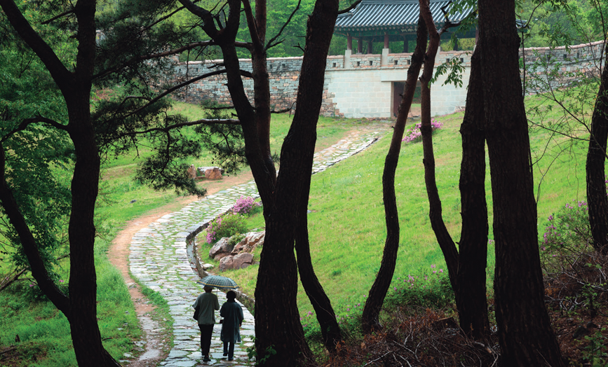
A mountain pass that is so high that even the birds struggle to fly over. A natural fort to defend the capital against attacks from the south. These are common descriptions of Mungyeong Saejae, or the “Bird Pass of Mungyeong.” We walk along the storied mountain paths in this scenic inland region, which were used centuries ago by ordinary travelers and emissaries.
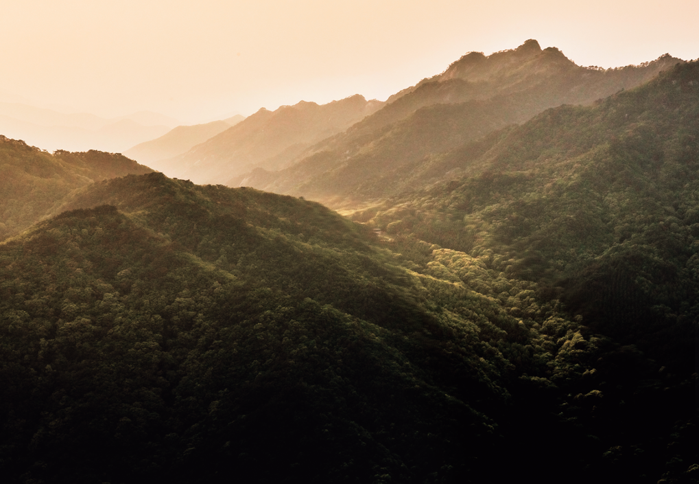
Mungyeong Saejae (Bird Pass of Mungyeong) seen from above at the highest spot along the Great Yeongnam Road. Located some two hours from Seoul by car, the mountain pass was a vital gateway for travelers and a military stronghold from the Three Kingdoms period (57 B.C.–A.D. 668) through the Joseon Dynasty (1392–1910). Today, it is a popular travel destination celebrated for its natural beauty and rich cultural heritage.
About 70 percent of Korea’s terrain is mountainous and most mountain ranges are a series of peaks and watersheds. Interestingly, the contours of a watershed may bestow special status to a mountain range. If streaming water separates at the top of a hill and flows down two sides into different rivers, the drainage pattern is considered auspicious. That is seen in the chain of mountain ridges that starts at Mt. Baekdu (also spelled Mt. Paektu) in the northernmost part of the Korean peninsula. It forms a famous watershed crest line called Baekdu Daegan, or the “Great White Head Ridges,” which stretches southward to Mt. Jiri, more than 1,600 kilometers away. Trekkers tackle the ridges constantly.
In 1861, during the Joseon Dynasty, the famous geographer and cartographer Kim Jeong-ho (1804–1866) produced a detailed topographical map of Korea using a modern scale. Carved into wooden printing blocks for reproduction and distribution, it was named “Daedong yeojido,” meaning “Territorial Map of the Great East.” In this iconic map, the shape of the Baekdu Daegan and the nation’s rivers and towns resemble a dragon or the curves of the red-and-blue Taegeuk symbol in Korea’s national flag. It reflects Kim’s view of nature: The chain of mountain ridges forming the spine of the peninsula represents the nation’s nature and geography and the foundation for understanding its culture, society, history and environment. Indeed, Mt. Baekdu appears in the first verse of the national anthem and school songs almost unfailingly rhapsodize about inheriting the energy of nearby mountains.
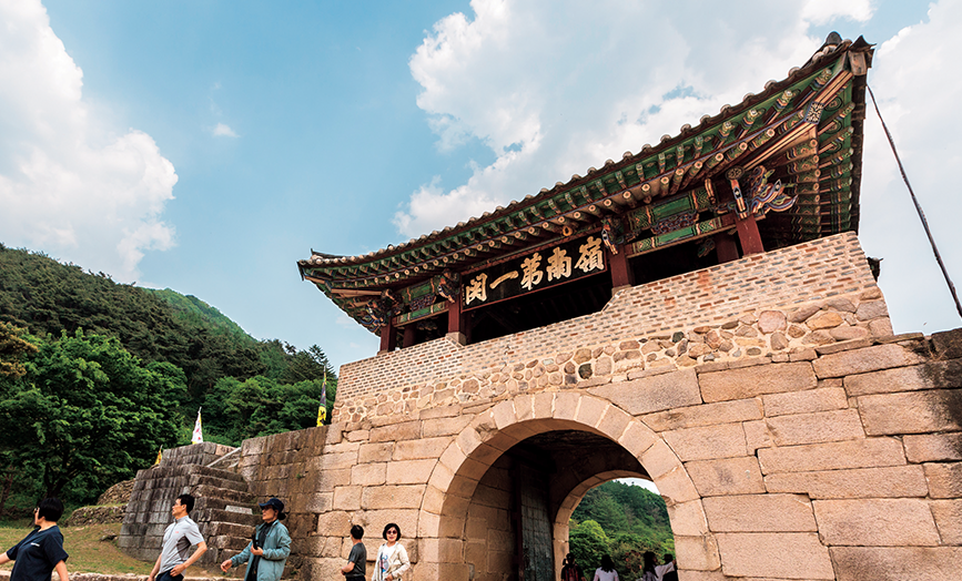
Juheulgwan is the first gate of Mungyeong Saejae. It was constructed in 1708 along with the Joryeong Mountain Fortress, after the Japanese and Manchu invasions underscored the strategic importance of the mountain pass.
Gomo Mountain Fortress was built around the fifth century A.D., when battles between the Three Kingdoms were rife. The original fortress walls were 1.6km long, only part of which remains today.
Link of This World and the Next
After a 20-minute drive south from Suanbo, a hot spring village in Chungju, in central Korea, an old town appears. There, a winding path leads to the site of an ancient temple, named Mireuk Daewon (Great Maitreya Monastery), once a manifestation of the glory of the Goryeo Dynasty (918–1392). A damaged stone pagoda and a giant stone statue of the bodhisattva Maitreya still stand. Past the temple grounds, stone markers point the way to Haneuljae (Sky Pass), a low hill that is start of the oldest hill path in Korea’s recorded history. It leads down to Mungyeong, the region’s administrative, transportation and economic hub.
The forest along the meandering path is dense but not overwhelming. The path itself is easy and pleasant, and the footsteps naturally slow down while the eyes rest leisurely on the fantastically shaped trees and the wildflowers blooming between the rocks.
From here, when it rains, the water flows down the Mungyeong side of the hill, spilling into the Nakdong River, or the Chungju side, joining the Han River. The land on the Chungju side is called Mireuk-ri (Maitreya Village), the embodiment of the next world; the Mungyeong side is called Gwaneum-ri (Avalokitesvara Village), the embodiment of this world. The path down to Gwaneum-ri, unfortunately covered in asphalt, is also dotted with stone Buddhist statues.
To secure the water from the Han River, which runs through the Korean peninsula, the three ancient kingdoms — Baekje, Goguryeo and Silla — fought over this land for hundreds of years. At the time, Silla was a small state centered on the city of Gyeongju, with its royal authority remaining weak. Although this area was an important point along the road between borders, it was not always teeming with soldiers. From remote times, goods produced in the northern and southern parts of the Korean peninsula were transported over this hill path. Moreover, this byway took the Goguryeo monk Master Ado (Ado Hwasang) to Silla, where he introduced Buddhism. The village of Morye, the man known as the first Buddhist convert in Silla, who protected Master Ado when he first arrived to spread Buddhism, is now revered as a sacred site.
Some Silla people traveled to Changan (today’s Xian), the first capital of China’s Tang Dynasty, which was enjoying a golden age of the arts and culture. From Gyeongju, the safest route was to head to Mungyeong, passing through several cities on the way; cross over Haneuljae to Chungju; travel on the Han River to the west coast port of Dangeunpo; and finally board a sea vessel heading north.
Historical records say the esteemed Silla monks Wonhyo (617–686) and Uisang (625–702) made at least two round trips on this route. In 650, the 34-year-old Wonhyo set out with Uisang to cross Haneuljae, on their way to study in Tang China. But they were caught by border guards in Liao-dong, in today’s northeast China, and forced to return.
Ten years later, the pair attempted the trip again, but they became separated while waiting for a boat at Dangeunpo. Wonhyo had to return while Uisang continued his journey to Tang. Wonhyo famously discovered that the sweet, fresh water he had drunk at night, while only half-awake, was rainwater that had been collected in a human skull. His realization that everything depends on the mind is found in the book, “Biographies of Eminent Korean Monks” (Haedong goseung jeon), published in 1215. Thereafter, at a time when the culture of the Tang and Sung dynasties was dominant, Wonhyo developed a unique system of thought and made other notable achievements in Korean Buddhism. Uisang, upon completing his studies in Tang, returned to Silla, where he helped Buddhism flourish.
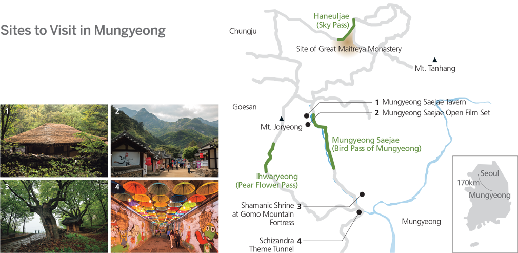
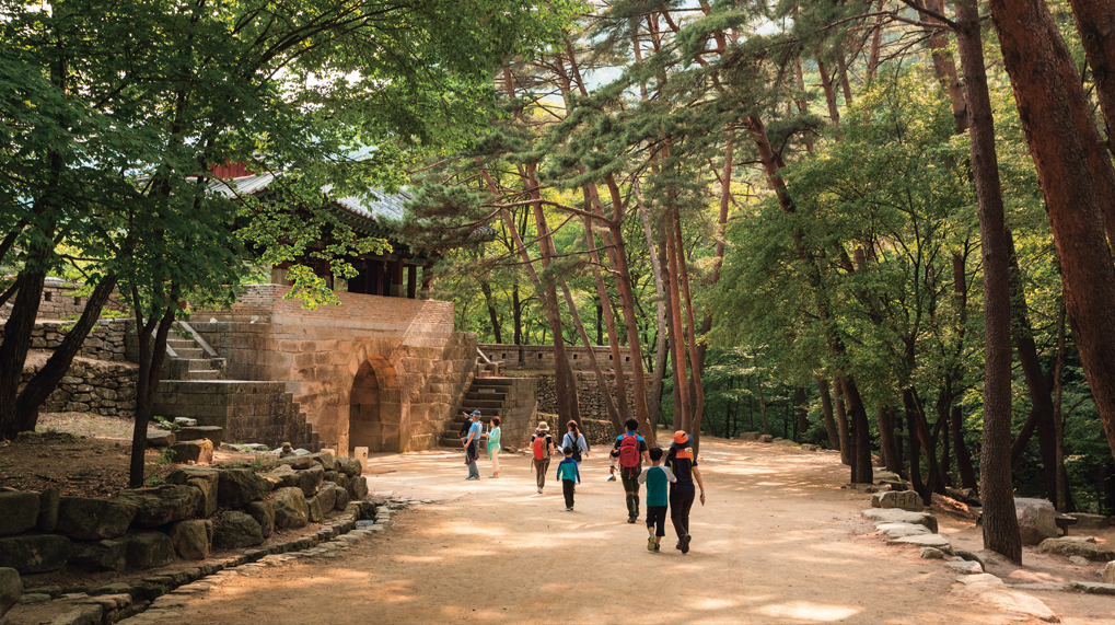
Jogokgwan, the second gate of Mungyeong Saejae, was built in 1594 with inner fortress walls. It was the earliest of the three gates built on the mountain pass. Its surrounding terrain is more rugged than that around the other gates.
A Steeper Road
During the Goryeo Dynasty, Mireuk Daewon was both a temple and popular travel destination. It served as a transit station and inn for government officials traveling on state business. The epitaph on the tomb of a lady with the family name Heo (1255–1324), wife of a man named Kim Byeon, gives us an idea of the mood of the times. When her husband died, the woman had a temple built near his tomb and commissioned hand-copied illuminated sutras in silver and gold ink. The projects continued for more than ten years to ensure the welfare of her husband in the next life. Then, at the age of 57, she undertook a pilgrimage to famous temples and mountains. Among her destinations was Mireuk Daewon. In Goryeo, where Buddhism was the state religion, men and women were treated for the most part as equal, so it was not unusual for women to be seen on such a journey.
From Haneuljae, a 40-minute climb southward brings you to the top of Mt. Tanhang. From here, following the gentle ridges and passing several peaks between the folds of the mountains, you can look down on Joryeonggwan, the third of three gates on Mungyeong Saejae. This place is also a drainage divide. When rain water from the roof of the gate flows down the northwest side to Chungju, it joins the Han River. If it falls on the southeast side to Mungyeong, it flows into the Nakdong River. The road on this mountain pass links Chungju and Mungyeong, from Joryeonggwan at the top, past the second gateway, Jogokgwan, and finally to the first gate, Joheulgwan. Walking from Haneuljae to Mungyeong Saejae along the ridges takes half a day.
Mungyeong Saejae was widely explored in the early days of Joseon, and for the following 500 years, it was a famous mountain pass, an important part of Yeongnam Daero (Great Yeongnam Road) stretching from Hanyang (today’s Seoul) to Dongnae (today’s Busan). The question is, why did the people of Joseon switch from the relatively flatter Haneuljae, a road that had been used for more than a thousand years, to Mungyeong Saejae, which was much steeper and some 100 meters higher?
Haneuljae had the advantage of being a route to the Han River ports frequented by boats that transported tribute grains, or grains paid as taxes. But as Goryeo waned after the decline of the Yuan Dynasty, which was once so strong as to pose a threat to Japan, Japanese pirates took over the seas. Pillaging by the pirates became rampant and water traffic gradually diminished. When the Mongols and the Red Turbans invaded, Haneuljae failed to function as a line of defense. In contrast, Mungyeong Saejae was a treacherous road, advantageous in defense, and a shorter overland route.
A Road for Confucian Scholars
Japanese pirates rampaged until the early Joseon Dynasty (1392–1910). King Taejong (r. 1400–1418), the third ruler of Joseon, used military force and trade to curb the pirates, and also concentrated on building a network of roads across the country for speedy communication and transportation. He established guarded post stations (yeokcham), where government officials traveling on state business could get fresh horses and accommodation. Unlike Goryeo, which set up stations or inns at natural points such as high mountains or river crossings, Joseon built them systematically, a station at every 30 li (approx. 12km) and an inn at every 10 li (approx. 4km). It was around this time that Mungyeong Saejae was incorporated into the Great Yeongnam Road. Using this mountain pass was faster than traveling via other hills or mountain roads. The road could only accommodate two people walking abreast, their shoulders bumping against one another with nearly every step. But in an agricultural society that did not need to move livestock, the route was wide enough.
The decision not to erect defense walls when the road was built is hard to understand. When Japanese troops invaded in 1592 and speedily advanced northward, they could not be stopped at the ravine here, which should have functioned as a natural fort. Korean forces eventually lost to Japan in a cavalry battle over the pass in Chungju. News of this defeat led King Seonjo to abandon the capital and take refuge in Pyongyang and, later, even further north. The following year, at the advice of Chief State Councilor Ryu Seong-ryong (1542–1607), two defensive gates were built to protect the road. But it was not until the early 18th century, after the second Manchu invasion of 1636–37, that the three-gate system that we see today was established. From that time, there were no major wars, however, and the gates served as forts defending the outer regions and passages for envoys traveling on diplomatic missions.
Both Goryeo and Joseon inevitably experienced the vicissitudes of foreign aggression and war, but the life along the Mungyeong Saejae differed greatly in the two periods. In the Confucian state of Joseon, half of the country’s ten major cities were located by the Great Yeongnam Road, and Mungyeong Saejae was the mountain pass symbolic of some outstanding aspects of Joseon culture. While civil service exams for the selection of government officials were only occasionally held during the Goryeo period, they were held on a regular basis during the Joseon period, when it was imperative to pass the exams, called gwageo, to succeed in the world. Many Confucian scholars from the Yeongnam region, or today’s Gyeongsang provinces, set out on this road to exam venues, hearts filled with hope. Their exam results made their trip home either a triumphal march or a trudge filled with shame and sighs.
Confucian scholars also used the road to travel to the capital when they wanted to express admonitions to the king and correct wrongs. They would depart from Andong, the Confucian stronghold, carrying with them their written appeals for the palace. Four days were needed to pass Mungyeong Saejae and about three months at the least to return home with an answer to the appeals. In addition to the scholars, the stations, inns and taverns near the mountain pass were crowded with royal inspectors in disguise on secret missions to look around the provinces, officials delivering government documents, and men of leisure setting off to tour famed scenic spots around the country. Between the first and second gates is a pavilion where the outgoing provincial governor of Gyeongsang would meet the newly appointed governor for an official transfer of duties. In front of this pavilion is a small waterfall that was a popular subject of poets and artists.
Among prominent groups of travelers passing through this mountain path were the diplomatic missions to Japan. Putting aside the wounds of the Japanese invasions of 1592–98, Korea and Japan exchanged diplomatic missions to build peace. Each mission departing from Joseon was comprised of 400 to 600 individuals, who represented the country in terms of its knowledge and culture. The envoys departed from Seoul, passed through several cities before crossing Mungyeong Saejae and proceeded to Busan, where they boarded ships. As their meals and accommodations along the way were all borne by the local regions, the central government demanded the envoys use a different route when leaving and returning to ensure that no place was burdened twice.
When Japanese troops invaded in 1592 and speedily advanced northward, they could not be stopped at the ravine here, which should have functioned as a natural fort.
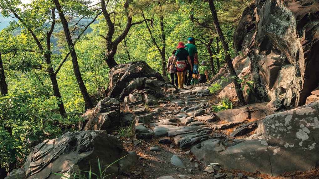
Tokkibiri (Rabbit’s Cliffside Road) is the most precipitous part of the Great Yeongnam Road. This section, carved out of rocky cliffs, is on the edge of a steep drop to the Yeong River. The stones forming the road surface have been worn smooth by the footsteps of the countless people who traveled the road over hundreds of years.
A Road of Anonymity
After passing through the third gate of Mungyeong Saejae, crossing over several rocky peaks and walking about 90 munites up a steep path with many steps, the top of 1,026-meter-high Mt. Joryeong (Bird Pass Mountain) can be reached. Some three kilometers southward down the hill from here is Ihwaryeong (Pear Flower Pass). This is another drainage divide. The water flowing down the Goesan side empties into the Han River, while the water that flows down the Mungyeong side spills into the Nakdong River.
Ihwaryeong was a hill so dangerous with wild animals that people waited until a group had gathered so they could ascend and descend together. As it was the only east-west road connecting Mungyeong in Gyeongsang Province with Goesan in Chungcheong Province, it is sure to have existed from early times but there are no historical records attesting to this. Elderly people say that when they were young they saw people carrying packs on their backs and cattle sellers driving herds of cattle crossing the pass. It thus can be surmised that it was a detour on the main mountain road leading to Chungju.
But who would have eschewed Mungyeong Saejae, a safer road with plenty of accommodations along the way, for a path that could only be crossed safely in a group? Most of them were peddlers, collectively called bobusang. Rather than a road thick with police who tried to find fault with them and extract bribes, the peddlers preferred to cross Ihwaryeong together, listening to the cries of mountain beasts. Though not a particularly respected class in history, the traveling vendors nevertheless often risked their lives and took the lead in acting when the nation was in crisis.
The old mountain pass was turned into a new road linking the Yeongnam region with Seoul in 1925, during the Japanese colonial period. Then, when the Ihwaryeong Tunnel was constructed in 1994 and the Jungbu Inland Expressway was built next to it in 2001, it became a quiet road that is sought out by hikers and cycling clubs.
Now, which of the three roads appeals to you the most?
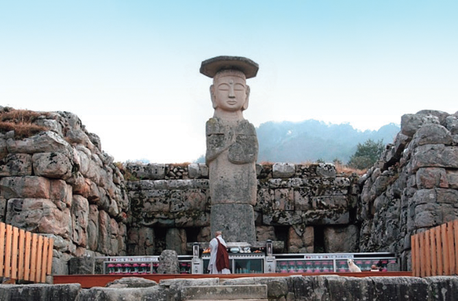
This 10.6-meter-high Stone Standing Buddha overlooks the site of Mireuk Daewon (Great Maitreya Monastery). The granite statue faces a 6-meter-high, five-story stone pagoda and a stone lantern. The monastery, presumably built during the early Goryeo Dynasty, combined the functions of a temple and inn for travelers.